

















Integrated Navigation for an 850,000 m² Rail-Overbuild Logistics Complex
Project Name: Shenzhen International Comprehensive Logistics Hub
Time: 2026
Quick Answer
Shenzhen International Comprehensive Logistics Hub combines warehousing, distribution and multimodal transport within a large rail-overbuild logistics environment in Shenzhen.
Its scale, long viewing distances, multiple functional zones and intensive vehicle circulation create navigation demands beyond conventional wayfinding. COSUN SIGN delivered a multi-layer signage system covering façade identification, wayfinding signage solutions, large-format warehouse identification, traffic visual signage, and management and safety information across the logistics complex.

Project Snapshot
| Project | Shenzhen International Comprehensive Logistics Hub |
| Location | Longgang District, Shenzhen, China |
| Project Type | Integrated Logistics Hub |
| Project Scale | 850,000 m² rail-overbuild logistics complex |
| Environment | Warehousing, distribution and multimodal logistics |
| Signage Scope | Façade illuminated signage, park wayfinding, wall identification, traffic visual signage, management and safety signage |
| Key Challenge | Large scale, multiple functional zones, long viewing distances and intensive vehicle circulation |
1. Why Wayfinding Matters in a Large Logistics Hub
A logistics hub is navigated differently from a conventional commercial building.
Drivers need to recognize destinations while moving. Warehouse zones must remain identifiable across long distances. Traffic information, loading areas, operational boundaries and safety instructions must also coexist within the same environment.
At Shenzhen International Comprehensive Logistics Hub, these demands occur across an unusually large site containing multiple logistics functions and circulation systems.
The signage challenge therefore extends beyond helping users find a destination.
Different information layers need to support a continuous navigation sequence—from identifying a building or zone to selecting a route and understanding the operational information associated with that area.
Engineering Note
In large logistics environments, wayfinding must organize spatial recognition and operational movement at the same time.
2. Understanding the Site and Its Navigation Challenges
The logistics hub combines transportation infrastructure and logistics space within a three-dimensional development.
Railway functions operate beneath the logistics complex, while warehousing, distribution facilities and surrounding road networks form the operational environment above and around the rail infrastructure.
This spatial structure creates several navigation challenges.
Large warehouse buildings can appear visually similar. Internal roads extend across multiple functional areas. Freight vehicles move between entrances, warehouses and operational zones, while staff and other users need to distinguish individual buildings and destinations.
Viewing distance creates another challenge.
Information that works at pedestrian scale can become visually weak against large industrial façades or along long internal roads. Signage therefore needs to communicate at several distances.
At long range, users need building and zone recognition. Along internal routes, they need directional information. Closer to individual facilities, operational, management and safety information becomes increasingly relevant.
Material Insight
Large industrial environments place greater emphasis on visibility, scale, installation conditions and environmental exposure. Signage engineering should therefore respond to where information is viewed and how each element interacts with the surrounding architecture.
3. Building a Wayfinding Information Hierarchy
For a logistics environment of this scale, individual signs are most useful when they belong to a clear information hierarchy.
The project signage can be understood across five levels:
Hub → Building / Zone → Route → Operational Area → Management & Safety Information
At the largest scale, façade identification creates recognizable building references.
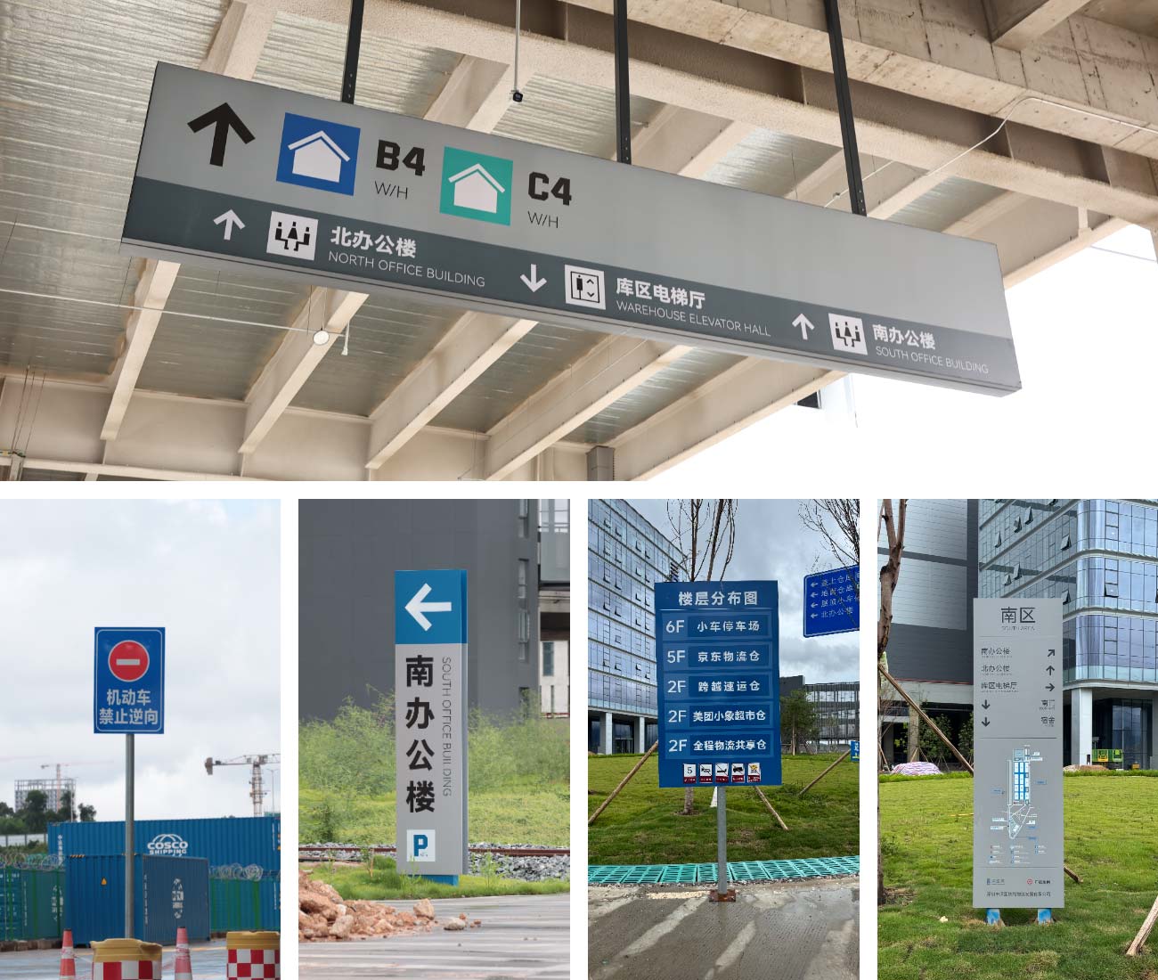
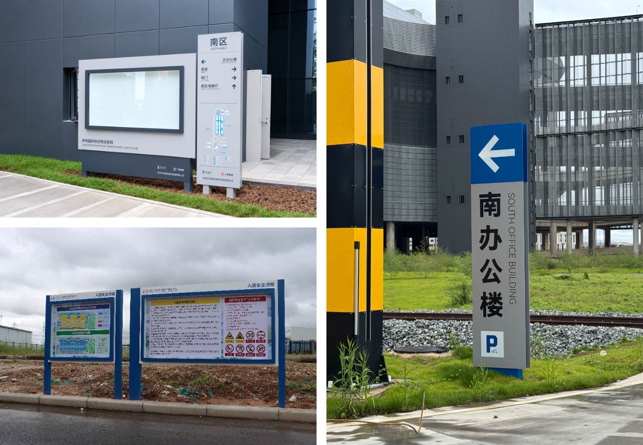
Within the park, directional signage connects entrances, internal roads and functional zones. Large-format wall identification distinguishes warehouse areas across longer viewing distances.
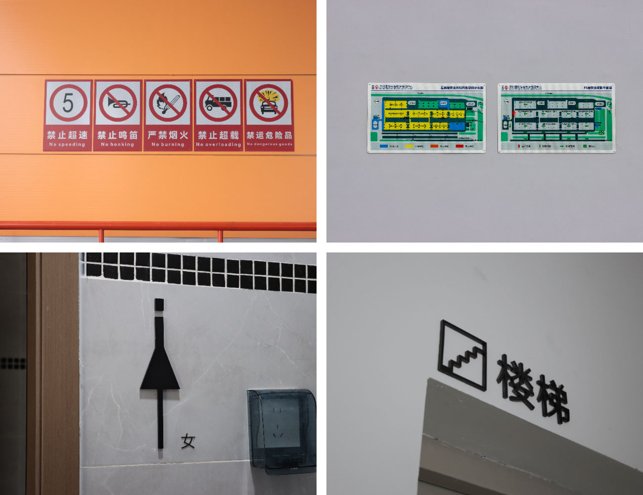
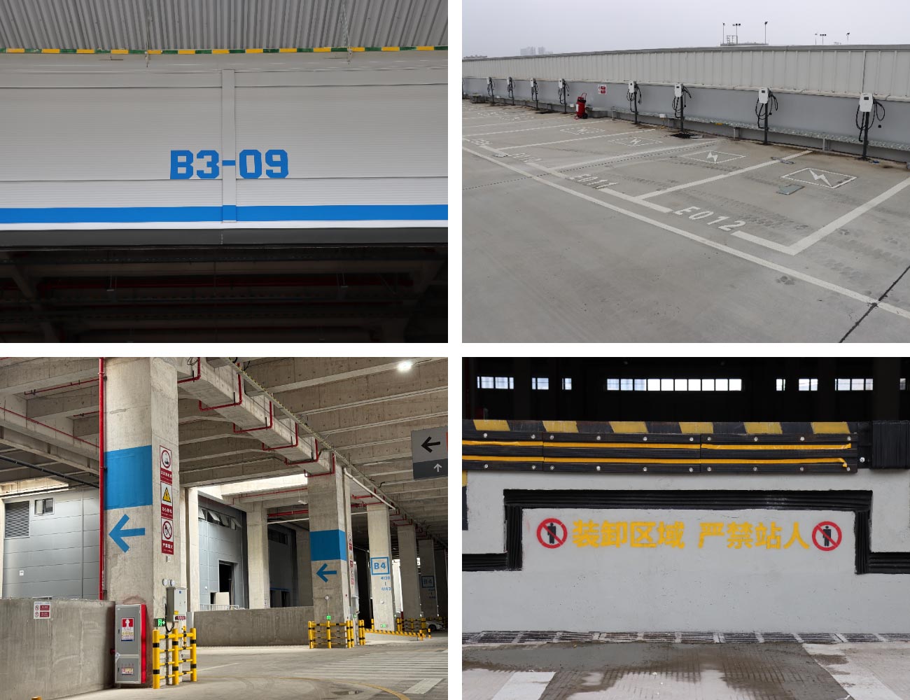
Closer to operational spaces, traffic visual signage communicates directions, parking areas, circulation zones and functional boundaries. Management and safety signs provide another information layer within individual work areas.
Information therefore becomes progressively more specific as users move through the logistics complex.
Engineering Principle
In logistics wayfinding, information should become progressively more specific as users move from site orientation to route selection and finally to operational instructions.
4. Façade Illuminated Signage for Long-Distance Building Recognition
Large logistics buildings are defined by scale, repetition and functional efficiency. Repeated warehouse volumes, however, can make individual buildings difficult to distinguish from a distance.
Façade identification therefore becomes part of the navigation system.
At Shenzhen International Comprehensive Logistics Hub, large illuminated building identification establishes visual reference points across the industrial environment. The signage needs to remain recognizable against extensive architectural elevations rather than operate at conventional pedestrian scale.
Large illuminated channel letters integrate identification with the building façade, connecting architectural identity with long-distance recognition.
For large commercial and industrial buildings, this type of elevated façade identification is also associated with sky signage, where letter scale, mounting position and viewing distance become critical to visibility.
The important engineering relationship is therefore not simply the size of the letters. It is the relationship between:
Viewing Distance → Building Scale → Signage Scale → Placement → Recognition
Engineering Note
Façade signage becomes part of wayfinding when it provides a recognizable architectural reference before users reach the immediate destination.
5. Turning Warehouse Architecture into Navigation
Building identification does not need to depend entirely on additional freestanding signs.
Within warehouse areas, large-format wall graphics integrate zone numbers and identification information directly into the architecture.
This turns large warehouse façades into information surfaces.
The approach is particularly relevant in industrial environments where long viewing distances can weaken conventional small-format identification. Typography, scale, positioning and contrast therefore need to correspond to the actual approach distance.
Consistent visual treatment also helps connect individual warehouse buildings to the wider signage hierarchy.
At road level, wayfinding signage solutions provide more immediate directional information, linking entrances, internal circulation routes and functional zones.
Architecture and signage therefore operate together at different scales rather than as independent visual systems.
6. Connecting Wayfinding with Traffic and Operations
Navigation in a logistics hub does not end when a driver identifies the correct warehouse.
Vehicle directions, parking areas, loading zones, operational boundaries and safety information continue to determine how the site is understood and used.
Traffic visual signage therefore forms an extension of the broader wayfinding system.
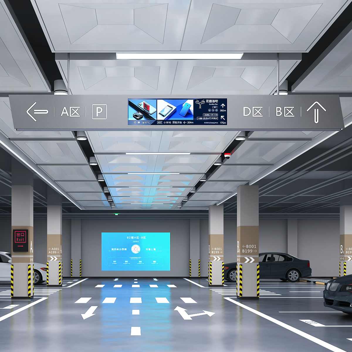
Across road and operational areas, directional information, parking identification, circulation markings and functional boundaries help distinguish different types of movement and use.
Management and safety signage adds another layer within individual operational areas, communicating facility rules, safety requirements and functional information where they become relevant.
Together, these elements create a continuous information sequence:
Building Recognition → Spatial Orientation → Route Guidance → Operational Identification → Management & Safety Information
Project Observation
The project demonstrates how building-scale identification, directional signage, traffic information and operational communication can work at different spatial scales while remaining part of one information hierarchy.
7. Maintaining Consistency Across Multiple Signage Types
A large logistics complex requires signage at very different physical scales.
Façade identification interacts with major architectural elevations. Park wayfinding appears across multiple road locations. Large-format wall graphics need to remain visually consistent across extensive warehouse surfaces, while management and safety information is repeated throughout operational areas.
For a signage manufacturer, the challenge is therefore not simply producing individual signs.
Different signage types need to preserve a recognizable visual logic across different sizes, applications and environments.
Consistency in typography, proportions, information hierarchy and visual treatment allows separate components to function as parts of the same system.
For complex industrial projects, this manufacturing consistency supports the continuity of the wayfinding system across widely separated locations.
Engineering Note
In large industrial projects, manufacturing consistency supports wayfinding consistency because repeated components need to communicate the same information logic across the entire site.
8. Engineering Lessons from the Project
Lesson One — Organize Movement Before Designing Individual Signs
Large logistics facilities contain overlapping vehicle, warehouse and operational movement systems.
The information hierarchy should first establish what users need to recognize at each stage—from site arrival and zone identification to route selection and operational information.
Individual signs can then serve a defined role within the larger navigation sequence.
Lesson Two — Use Architecture as Part of the Navigation System
Large industrial façades can become part of the information infrastructure.
Building-scale illuminated identification and large-format wall graphics allow architecture itself to support spatial orientation, particularly where conventional small signs would be visually weakened by long viewing distances.
Lesson Three — Extend Wayfinding into Daily Operations
Wayfinding does not stop at destination identification.
Traffic directions, parking areas, operational boundaries, management information and safety communication continue to shape how a logistics environment is understood.
These information layers work most coherently when they operate as extensions of the broader navigation system.
Project Specifications
| Category | Application |
| Façade Identification | Large-scale illuminated building identification |
| Wayfinding | Park directional and zone identification signage |
| Warehouse Identification | Large-format wall graphics and building identification |
| Traffic Information | Vehicle directions, parking, circulation and operational-area identification |
| Management Information | Operational and facility-management signage |
| Safety Information | Safety, fire and behavioral information |
| Application Areas | Building façades, internal roads, warehouse zones and operational spaces |
Engineering Questions About Logistics Hub Wayfinding
What makes wayfinding difficult in a large logistics hub?
Large logistics hubs combine long viewing distances, repeated warehouse architecture, intensive vehicle circulation and multiple operational zones.
An effective wayfinding system therefore needs to organize building recognition, zone identification, route selection and operational information across different spatial scales.
How should warehouse zones be identified from longer distances?
Warehouse identification should respond to the distance and direction from which users approach the building.
Large-format façade graphics and building-scale identification can turn architectural surfaces into part of the navigation system, helping zone information remain visually distinct across large industrial environments.
What is the role of façade illuminated signage in a logistics hub?
Façade illuminated signage can establish long-distance building reference points before users reach individual warehouse or operational areas.
Large illuminated channel letters and appropriately scaled sky signage can support architectural identification where the viewing distance is significantly greater than in conventional pedestrian environments.
Why should traffic information be integrated with logistics wayfinding?
Drivers continue making movement decisions after identifying the correct building.
Directional information, parking areas, circulation zones and operational boundaries therefore need to connect with the broader navigation hierarchy instead of functioning as isolated traffic graphics.
What information should a logistics wayfinding system organize?
A large logistics wayfinding system may need to coordinate five information levels:
Site Orientation → Building / Zone Identification → Route Guidance → Operational Information → Management & Safety Information
The information becomes more specific as users move closer to their destination.
Related Industrial & Campus Wayfinding Projects
DNE LASER Smart Manufacturing Campus
A smart manufacturing campus project connecting architectural identity, campus navigation and corporate environments through an integrated signage system.
Baolong Specialized and Innovative Industrial Park
An industrial campus project addressing spatial identification and navigation within a vertically developed manufacturing environment.
Biological Home Life Science Campus
A science and technology campus where wayfinding connects architecture, landscape and multiple functional areas.
About COSUN SIGN
COSUN SIGN is a signage manufacturer in China providing architectural signage, building identification and wayfinding signage solutions for corporate, commercial, industrial and transportation environments.
Combining engineering development, manufacturing and project delivery, COSUN develops signage systems that respond to architecture, movement and operational requirements across complex built environments.
Its manufacturing capabilities include custom architectural signage and illuminated channel letters, supporting projects from building-scale identification to integrated wayfinding systems.
Planning a Complex Logistics or Industrial Environment?
How can signage connect building identification, vehicle movement and daily operations across a large logistics facility?
Early coordination between circulation, architecture, signage and operational requirements can establish a clearer information hierarchy before individual signage elements are developed.
Discuss your industrial wayfinding project with the COSUN SIGN engineering team before detailed design begins.





 粤公网安备44030702001648号